The Trinidad and Tobago Meteorological Service (TTMS) has been monitoring the progress of a strong Tropical Wave in the Atlantic, which has the potential for cyclone development over the next few days.
At 2:00 am this morning (Monday 27th June, 2022) the axis of this wave was located near 45W.
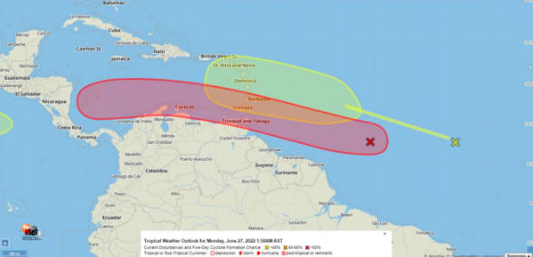
Showers and thunderstorm activity associated with this tropical wave located about 950 miles east-southeast of the Windward Islands has increased.
Environmental conditions appear conducive for further development, and a tropical depression is likely to form during the next couple of days before the system reaches the Windward Islands Tuesday night or possibly while moving westward across the southern Caribbean Sea Wednesday through Friday.
A NOAA Hurricane Hunter aircraft is scheduled to investigate the system this afternoon.
Interests in the Windward Islands should closely monitor the progress of this system. The chance of tropical cyclone formation is high (70%) during the next 48hours, and also high (90%) over the next 5 days (refer to Figure 1).
Regardless of development of the system significant moisture associated with this system will bring heavy rainfall and gusty winds to Trinidad and Tobago and the Windward Islands from Tuesday night into Wednesday morning.
There are no watches or warnings in effect at this time.