The T&T Met Service is monitoring several areas of interest in the Tropical Atlantic Ocean.
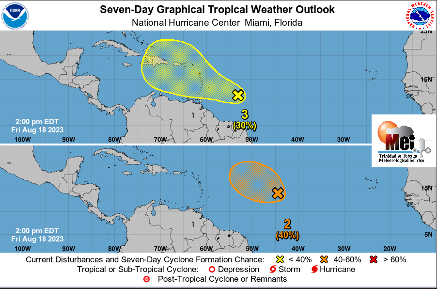
The first is an elongated trough of low pressure is located about 700km ESE of the Lesser Antilles (labelled 3 in attached #gure). This area will move across the Lesser Antilles into the Caribbean Sea over the weekend or early next week.
There is slow development and the NHC has placed a low chance (10 to 30%) of cyclone formation over the next few days. This trough is producing patches of showers and thunderstorms over a broad area. Further east is another elongated trough of low pressure (AL99) in the central Tropical Atlantic (labelled 2 in attached #gure), about 1500 km east of the Lesser Antilles has a medium chance (40%) of cyclone formation over the next few days. This trough is producing disorganized showers and thunderstorms.
However the Met Office also stressed that: THERE ARE CURRENTLY NO ALERTS, WATCHES AND WARNING IN EFFECT FOR TRINIDAD AND TOBAGO. The forecast for the weekend over Trinidad and Tobago is for partly cloudy to cloudy skies with intermittent showers and the medium to high (60 to 80%) chance of heavy showers and thunderstorms.
The TTMS continues to monitor these areas and will issue an update at 3 p.m. tomorrow, Saturday 19th August, 2023 or earlier if the situation warrants.